Where Is It?

-
railrod1949
- Railroadfan...fan
- Posts: 1317
- Joined: Mon Oct 26, 2015 8:19 am
- Location: Waterford, MI
-
MQT1223

- O Scale Railfanner
- Posts: 4073
- Joined: Wed Sep 10, 2014 1:46 pm
- Location: Grandville, Michigan
- Contact:
Re: Where Is It?
That track was still in place beyond Linden Rd all the way to Ballenger Hwy up until about 2010 or so. The crossings and everything was intact, including a brand new setup at the nearby Lennon Rd crossing that was removed. For a long time there was a large "For Sale" sign at the former Ballenger crossing with GTW (not CN) being advertised as the seller. The largest crossing was a 5 track crossing at Utley Rd just east of the I-75 overpass governed by crossbucks. There was also a yard between Corunna Rd and Utley Rd. All of this started to come out and the bridge over I-75 was torn out about 5 years ago for what I guess was integrity reasons. Everything from Linden Rd all the way to the former auto plant locations on Flint's west side are now a part of what I believe is the Flint River Trail. Its a nice trail but a lot of it runs through rough neighborhoods. Flint is doing its best to turn some of the area by the old automotive plants into greenspace and parks.
1223 OUT! President and Founder of the Buck Creek Central, the Rolling River Route! (2012-2017) President and Founder of the Lamberton Valley Railroad, The Tin Plate Road! Proudly railfanning with Asperger's since 1996. 
-
DaveO
- Read more, think more, post less
- Posts: 1464
- Joined: Thu Dec 14, 2017 12:57 pm
- Location: Between here and there
Re: Where Is It?
bridge gone in street view September 2008. that section abandoned 2006.MQT1223 wrote: ↑Sat Sep 12, 2020 5:40 pmThat track was still in place beyond Linden Rd all the way to Ballenger Hwy up until about 2010 or so. The crossings and everything was intact, including a brand new setup at the nearby Lennon Rd crossing that was removed. For a long time there was a large "For Sale" sign at the former Ballenger crossing with GTW (not CN) being advertised as the seller. The largest crossing was a 5 track crossing at Utley Rd just east of the I-75 overpass governed by crossbucks. There was also a yard between Corunna Rd and Utley Rd. All of this started to come out and the bridge over I-75 was torn out about 5 years ago for what I guess was integrity reasons. Everything from Linden Rd all the way to the former auto plant locations on Flint's west side are now a part of what I believe is the Flint River Trail. Its a nice trail but a lot of it runs through rough neighborhoods. Flint is doing its best to turn some of the area by the old automotive plants into greenspace and parks.
-
MQT1223
- O Scale Railfanner
- Posts: 4073
- Joined: Wed Sep 10, 2014 1:46 pm
- Location: Grandville, Michigan
- Contact:
Re: Where Is It?
Couldn't have been 2008... it was about the time the trail started being built. I remember because my dad's fiance lived right around the corner from that bridge up until 2018. You sure your looking at the right bridge? 2006 would make sense given that everything was largely intact up until that point. What was it being used for up to its abandonment?DaveO wrote: ↑Sat Sep 12, 2020 7:10 pmbridge gone in street view September 2008. that section abandoned 2006.MQT1223 wrote: ↑Sat Sep 12, 2020 5:40 pmThat track was still in place beyond Linden Rd all the way to Ballenger Hwy up until about 2010 or so. The crossings and everything was intact, including a brand new setup at the nearby Lennon Rd crossing that was removed. For a long time there was a large "For Sale" sign at the former Ballenger crossing with GTW (not CN) being advertised as the seller. The largest crossing was a 5 track crossing at Utley Rd just east of the I-75 overpass governed by crossbucks. There was also a yard between Corunna Rd and Utley Rd. All of this started to come out and the bridge over I-75 was torn out about 5 years ago for what I guess was integrity reasons. Everything from Linden Rd all the way to the former auto plant locations on Flint's west side are now a part of what I believe is the Flint River Trail. Its a nice trail but a lot of it runs through rough neighborhoods. Flint is doing its best to turn some of the area by the old automotive plants into greenspace and parks.
1223 OUT! President and Founder of the Buck Creek Central, the Rolling River Route! (2012-2017) President and Founder of the Lamberton Valley Railroad, The Tin Plate Road! Proudly railfanning with Asperger's since 1996.
-
DaveO
- Read more, think more, post less
- Posts: 1464
- Joined: Thu Dec 14, 2017 12:57 pm
- Location: Between here and there
Re: Where Is It?
The bridge was removed before the track to it was removed. IIRC, it was removed concurrent with rehab work MDOT was doing on that stretch of I-75.MQT1223 wrote: ↑Sun Sep 13, 2020 8:48 pmCouldn't have been 2008... it was about the time the trail started being built. I remember because my dad's fiance lived right around the corner from that bridge up until 2018. You sure your looking at the right bridge? 2006 would make sense given that everything was largely intact up until that point. What was it being used for up to its abandonment?DaveO wrote: ↑Sat Sep 12, 2020 7:10 pmbridge gone in street view September 2008. that section abandoned 2006.MQT1223 wrote: ↑Sat Sep 12, 2020 5:40 pmThat track was still in place beyond Linden Rd all the way to Ballenger Hwy up until about 2010 or so. The crossings and everything was intact, including a brand new setup at the nearby Lennon Rd crossing that was removed. For a long time there was a large "For Sale" sign at the former Ballenger crossing with GTW (not CN) being advertised as the seller. The largest crossing was a 5 track crossing at Utley Rd just east of the I-75 overpass governed by crossbucks. There was also a yard between Corunna Rd and Utley Rd. All of this started to come out and the bridge over I-75 was torn out about 5 years ago for what I guess was integrity reasons. Everything from Linden Rd all the way to the former auto plant locations on Flint's west side are now a part of what I believe is the Flint River Trail. Its a nice trail but a lot of it runs through rough neighborhoods. Flint is doing its best to turn some of the area by the old automotive plants into greenspace and parks.
Corunna Yard saw some usage as car storage near the end.
-
MQT1223
- O Scale Railfanner
- Posts: 4073
- Joined: Wed Sep 10, 2014 1:46 pm
- Location: Grandville, Michigan
- Contact:
Re: Where Is It?
The track came out first, save for the crossings. The bridge came out during its own little project well afterwords. Due to the nature of the area it had become a habit for people to walk across it or go around the gates on either end, I even saw a car cross it once.
I'm surprised another bridge wasn't erected in its place, but with a nearby overpass on surface streets it was probably a cheaper long term solution.
I want to say the bridge came down around 2012.
1223 OUT! President and Founder of the Buck Creek Central, the Rolling River Route! (2012-2017) President and Founder of the Lamberton Valley Railroad, The Tin Plate Road! Proudly railfanning with Asperger's since 1996.
Re: Where Is It?
The trail uses the M21 overpass to cross the freeway, and connects back before crossing over Graham Road.
The students at Kettering seem to use the trail the most, especially over near Chevrolet Avenue. That area around the university isnt bad by Flint standards.
The students at Kettering seem to use the trail the most, especially over near Chevrolet Avenue. That area around the university isnt bad by Flint standards.
-
DaveO
- Read more, think more, post less
- Posts: 1464
- Joined: Thu Dec 14, 2017 12:57 pm
- Location: Between here and there
Re: Where Is It?
Notice the google street view image date of September 2008 and the bridge is gone.MQT1223 wrote: ↑Fri Sep 18, 2020 8:39 pmThe track came out first, save for the crossings. The bridge came out during its own little project well afterwords. Due to the nature of the area it had become a habit for people to walk across it or go around the gates on either end, I even saw a car cross it once.
I'm surprised another bridge wasn't erected in its place, but with a nearby overpass on surface streets it was probably a cheaper long term solution.
I want to say the bridge came down around 2012.
https://goo.gl/maps/vpogty23ncaNmxGR9
It appears the track near and east of I-75 was removed concurrent with the bridge removal.
-
MQT1223
- O Scale Railfanner
- Posts: 4073
- Joined: Wed Sep 10, 2014 1:46 pm
- Location: Grandville, Michigan
- Contact:
Re: Where Is It?
Man... it sure didn't seem that long ago...DaveO wrote: ↑Fri Sep 18, 2020 9:51 pmNotice the google street view image date of September 2008 and the bridge is gone.MQT1223 wrote: ↑Fri Sep 18, 2020 8:39 pmThe track came out first, save for the crossings. The bridge came out during its own little project well afterwords. Due to the nature of the area it had become a habit for people to walk across it or go around the gates on either end, I even saw a car cross it once.
I'm surprised another bridge wasn't erected in its place, but with a nearby overpass on surface streets it was probably a cheaper long term solution.
I want to say the bridge came down around 2012.
https://goo.gl/maps/vpogty23ncaNmxGR9
It appears the track near and east of I-75 was removed concurrent with the bridge removal.
1223 OUT! President and Founder of the Buck Creek Central, the Rolling River Route! (2012-2017) President and Founder of the Lamberton Valley Railroad, The Tin Plate Road! Proudly railfanning with Asperger's since 1996.

Re: Where Is It?
PatC created a monster, 'cause nobody wants to see Don Simon no more they want AARR I'm chopped liver, well if you want AARR this is what I'll give ya, bad humor mixed with irrelevant info that'll make you roll your eyes quicker than a ~Z~ banhammer...
-
Michael
- Railroadfan...fan
- Posts: 10864
- Joined: Sun Sep 12, 2010 2:52 pm
- Location: Plymouth, Michigan
Re: Where Is It?
It is the UP but Newberry is cold.
Re: Where Is It?
Iron Mountain?
PatC created a monster, 'cause nobody wants to see Don Simon no more they want AARR I'm chopped liver, well if you want AARR this is what I'll give ya, bad humor mixed with irrelevant info that'll make you roll your eyes quicker than a ~Z~ banhammer...
-
Buster Manning
- Railroadfan...fan
- Posts: 676
- Joined: Tue Aug 25, 2009 10:16 pm
Re: Where Is It?
concur.... W. Brown St in Iron Mountain
If you were to back up the Google view, it shows a NB train going thru here
If you were to back up the Google view, it shows a NB train going thru here
-
railrod1949
- Railroadfan...fan
- Posts: 1317
- Joined: Mon Oct 26, 2015 8:19 am
- Location: Waterford, MI
Re: Where Is It?
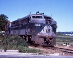
Yes, E Brown Street, Iron Mountain, MI looking north along the E&LS RR( former the Milwaukee Road RR) towards Channing and Champion, MI. In Iron Mountain, Dickinson County. Final run of the remaining passenger train on the former the Milwaukee Road train nos9/10 the Copper Country Limited between Chicago and Calumet, MI with stop in Iron Mountain at 10:00pm southbound and 3:30am northbound, was made on March 7 and 8, 1968.Buster Manning wrote: ↑Mon Sep 21, 2020 3:12 pmconcur.... W. Brown St in Iron Mountain
If you were to back up the Google view, it shows a NB train going thru here
-
Michael
- Railroadfan...fan
- Posts: 10864
- Joined: Sun Sep 12, 2010 2:52 pm
- Location: Plymouth, Michigan
Re: Where Is It?
Well done guys. You are correct Buster https://goo.gl/maps/AAc2GcwytcZoFfvc8
-
ConrailDetroit
- Railroadfan...fan
- Posts: 5923
- Joined: Sun Apr 29, 2007 10:04 pm
- Location: Detroit

-
railrod1949
- Railroadfan...fan
- Posts: 1317
- Joined: Mon Oct 26, 2015 8:19 am
- Location: Waterford, MI
Re: Where Is It?
Somewhere along the Detroit River, Detroit.