Page 326 of 562
Re: Where Is It?
Posted: Wed Aug 16, 2017 8:16 pm
by railrod1949
East side of US-131 over the Grand Elk track to the Otsego Paper Mill. Just north of Plainwell, in the Plainwell Community Schools district, Gunplain Township, Allegan County. Plainwell, MI 49080.
Re: Where Is It?
Posted: Wed Aug 16, 2017 11:36 pm
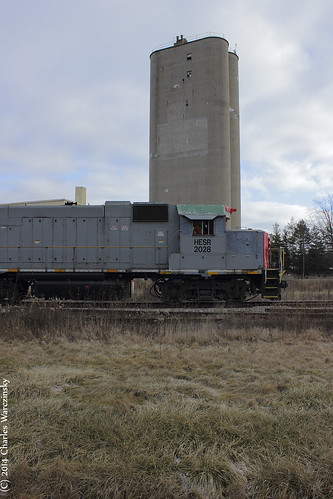
by GreatLakesRailfan
Marlette.
Michael wrote:On the HESR in the thumb
GreatLakesRailfan wrote:This is an active mystery location?
Ugh, when I first saw it earlier I misread the post, thinking it was another shot from Hamburg...but it kinda looks like Durand.
Michael wrote:

Re: Where Is It?
Posted: Wed Aug 16, 2017 11:38 pm
by GreatLakesRailfan
railrod1949 wrote:Michael wrote:It is not Munger
Brown City on M-90; Croswell or Carsonville. Or is at the end of the track on HESR.
There's no elevator in Carsonville anymore, Rodney. It's a thrift store or something now. Most of the tall stuff came down a decade or so ago (hard to believe it's really been that long).
Re: Where Is It?
Posted: Thu Aug 17, 2017 8:03 am
by AARR
I think Michael said this picture is from 2008 so the building in the background may have still been an elevator back then
GreatLakesRailfan wrote:railrod1949 wrote:Michael wrote:It is not Munger
Brown City on M-90; Croswell or Carsonville. Or is at the end of the track on HESR.
There's no elevator in Carsonville anymore, Rodney. It's a thrift store or something now. Most of the tall stuff came down a decade or so ago (hard to believe it's really been that long).
Re: Where Is It?
Posted: Thu Aug 17, 2017 8:17 am
by Burb8145
railrod1949 wrote:East side of US-131 over the Grand Elk track to the Otsego Paper Mill. Just north of Plainwell.
Correct.
Re: Where Is It?
Posted: Thu Aug 17, 2017 2:10 pm
by GreatLakesRailfan
AARR wrote:I think Michael said this picture is from 2008 so the building in the background may have still been an elevator back then
It's not Carsonville. This is what was left of the elevator in 2014. It's nothing like the elevator in the picture.
Re: Where Is It?
Posted: Fri Aug 18, 2017 6:40 am
by Michael
All the guesses are wrong so far. The elevator is still there just not an active customer anymore ( I could be wrong)
Does this view help?

Re: Where Is It?
Posted: Fri Aug 18, 2017 8:11 am
by railrod1949
Michael wrote:All the guesses are wrong so far. The elevator is still there just not an active customer anymore ( I could be wrong)
Does this view help?
Yes, it is Michael, found it finally! Unionville looking east on M-25 toward downtown Unionville and the intersection with M-24 in the Unionville-Sebewaing Area School district, Tuscola County.
Re: Where Is It?
Posted: Fri Aug 18, 2017 8:12 am
by AARR
What is the town between Palms and Ruth? Minden City? That's my guess.
Michael wrote:All the guesses are wrong so far. The elevator is still there just not an active customer anymore ( I could be wrong)
Does this view help?
Re: Where Is It?
Posted: Fri Aug 18, 2017 7:48 pm
by GreatLakesRailfan
railrod1949 wrote:Michael wrote:All the guesses are wrong so far. The elevator is still there just not an active customer anymore ( I could be wrong)
Does this view help?
Yes, it is Michael, found it finally! Unionville looking east on M-25 toward downtown Unionville and the intersection with M-24 in the Unionville-Sebewaing Area School district, Tuscola County.
Rodney's got it. The last time I was up there, that elevator was a lot more overgrown than it was in Michael's Google photos. I think it was also shut down, whereas it was open back in 2008ish.
Re: Where Is It?
Posted: Fri Aug 18, 2017 10:32 pm
by Burb8145
This is somewhere in one of Michigan's largest cities and the track photographed here is used by Amtrak, among other trains.

Re: Where Is It?
Posted: Sat Aug 19, 2017 8:14 am
by railrod1949
Burb8145 wrote:This is somewhere in one of Michigan's largest cities and the track photographed here is used by Amtrak, among other trains.
W. 12th Street and Hammerberg Road, looking south between I-75 and I-475, just south of the I-69 interchange with Hammerberg Road. Amtrak Train#365 departed Flint five minutes ago. 44 minutes late.
Re: Where Is It?
Posted: Sat Aug 19, 2017 8:41 am
by GTW6401
This is somewhere in one of Michigan's largest cities and the track photographed here is used by Amtrak, among other trains.
12th Street and Hammerberg Road. Flint
Re: Where Is It?
Posted: Sat Aug 19, 2017 9:25 am
by Burb8145
railrod1949 wrote:Burb8145 wrote:This is somewhere in one of Michigan's largest cities and the track photographed here is used by Amtrak, among other trains.
W. 12th Street and Hammerberg Road, looking south between I-75 and I-475, just south of the I-69 interchange with Hammerberg Road. Amtrak Train#365 departed Flint five minutes ago. 44 minutes late.
GTW6401 wrote:This is somewhere in one of Michigan's largest cities and the track photographed here is used by Amtrak, among other trains.
12th Street and Hammerberg Road. Flint
Both of you got it, I never thought it would be
this easy.
Here's a tricky one for you. Many years ago there were tracks where the path going off into the horizon is.

Re: Where Is It?
Posted: Sat Aug 19, 2017 11:04 am
by railrod1949
Burb8145 wrote:railrod1949 wrote:Burb8145 wrote:This is somewhere in one of Michigan's largest cities and the track photographed here is used by Amtrak, among other trains.
W. 12th Street and Hammerberg Road, looking south between I-75 and I-475, just south of the I-69 interchange with Hammerberg Road. Amtrak Train#365 departed Flint five minutes ago. 44 minutes late.
GTW6401 wrote:This is somewhere in one of Michigan's largest cities and the track photographed here is used by Amtrak, among other trains.
12th Street and Hammerberg Road. Flint
Both of you got it, I never thought it would be
this easy.
Here's a tricky one for you. Many years ago there were tracks where the path going off into the horizon is.
Fred Meijer Trail, looking north from the E. Market Street crossing, two blocks south of the Flat River, east of Lafayette Blvd. (M-91) all in Greenville. Former C&O and Mid Michigan railroads.
Re: Where Is It?
Posted: Sat Aug 19, 2017 2:49 pm
by Mark F
Found it. Hint: Those are the bollards on the Fred Meijer Heartland Trail. This is on one of the newer sections of the trail.
Re: Where Is It?
Posted: Sat Aug 19, 2017 9:04 pm
by Burb8145
railrod1949 wrote:Fred Meijer Trail, looking north from the E. Market Street crossing, two blocks south of the Flat River, east of Lafayette Blvd. (M-91) all in Greenville. Former C&O and Mid Michigan railroads.
You got it...and I thought it was going to be tricky.
Well, here's an actually tricky one. Only one hint for now: northern Michigan.

Re: Where Is It?
Posted: Sun Aug 20, 2017 6:25 am
by railrod1949
Burb8145 wrote:railrod1949 wrote:Fred Meijer Trail, looking north from the E. Market Street crossing, two blocks south of the Flat River, east of Lafayette Blvd. (M-91) all in Greenville. Former C&O and Mid Michigan railroads.
You got it...and I thought it was going to be tricky.
Well, here's an actually tricky one. Only one hint for now: northern Michigan.
Somewhere on the LSRC between West Branch and Grayling.
Re: Where Is It?
Posted: Sun Aug 20, 2017 11:20 am
by Burb8145
railrod1949 wrote:Burb8145 wrote:Well, here's an actually tricky one. Only one hint for now: northern Michigan.
Somewhere on the LSRC between West Branch and Grayling.
Nope. This shot is further west.
Re: Where Is It?
Posted: Sun Aug 20, 2017 4:35 pm
by AANscaleRunner
Burb8145 wrote:railrod1949 wrote:Fred Meijer Trail, looking north from the E. Market Street crossing, two blocks south of the Flat River, east of Lafayette Blvd. (M-91) all in Greenville. Former C&O and Mid Michigan railroads.
You got it...and I thought it was going to be tricky.
Well, here's an actually tricky one. Only one hint for now: northern Michigan.
Great Lakes Central between Cadillac and Yuma.