Where Is It?
Re: Where Is It?
Newaygo? South of the current MAC location?
PatC created a monster, 'cause nobody wants to see Don Simon no more they want AARR I'm chopped liver, well if you want AARR this is what I'll give ya, bad humor mixed with irrelevant info that'll make you roll your eyes quicker than a ~Z~ banhammer...
Re: Where Is It?
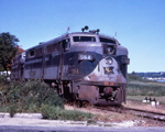
A well worn location. I saw this at the Newaygo city offices. Looking south toward the river. The building was Rowe Mfg who made wooden knobs and such for furniture. The foundations are still there. M82 crosses on a bridge between Rowe and the camera.

Re: Where Is It?
Odd to think a cattle guard was needed there.
https://www.flickr.com/photos/jimthias/
GRHC - you know every night I can imagine he is in front of his computer screen sitting in his underwear swearing profusely and drinking Blatz beer combing the RailRoadFan website for grammatical errors.
GRHC - you know every night I can imagine he is in front of his computer screen sitting in his underwear swearing profusely and drinking Blatz beer combing the RailRoadFan website for grammatical errors.
-
Michael
- Railroadfan...fan
- Posts: 10893
- Joined: Sun Sep 12, 2010 2:52 pm
- Location: Plymouth, Michigan
Re: Where Is It?
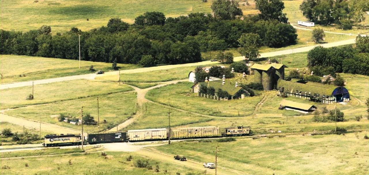
From 1985. Let's see if anyone recognizes this spot without any hints.
Re: Where Is It?
Is it between Saginaw and Port Huron?
PatC created a monster, 'cause nobody wants to see Don Simon no more they want AARR I'm chopped liver, well if you want AARR this is what I'll give ya, bad humor mixed with irrelevant info that'll make you roll your eyes quicker than a ~Z~ banhammer...
-
Michael
- Railroadfan...fan
- Posts: 10893
- Joined: Sun Sep 12, 2010 2:52 pm
- Location: Plymouth, Michigan
Re: Where Is It?
Nope. A present day photo would not look drastically different although the 4 silos are all that is left standing. It was part of a prison complex and a coal customer back in the day.
Re: Where Is It?
Ionia?
PatC created a monster, 'cause nobody wants to see Don Simon no more they want AARR I'm chopped liver, well if you want AARR this is what I'll give ya, bad humor mixed with irrelevant info that'll make you roll your eyes quicker than a ~Z~ banhammer...
Re: Where Is It?
A Google search of "Michigan prison silos" comes back with a location of 5 Mile Rd and Ridge Rd near Plymouth that seems to be a match.
-
DaveO
- Read more, think more, post less
- Posts: 1465
- Joined: Thu Dec 14, 2017 12:57 pm
- Location: Between here and there
Re: Where Is It?
DeHoCo. Love how the online sites I viewed state the buildings surrounding the silos were torn down in the 1930's.
I'm pretty sure Chessie System didn't exist until the 1970's
I'm pretty sure Chessie System didn't exist until the 1970's
-
Michael
- Railroadfan...fan
- Posts: 10893
- Joined: Sun Sep 12, 2010 2:52 pm
- Location: Plymouth, Michigan
Re: Where Is It?
They must have meant BUILT in the 1930 not torn down. Many of the building had dates on them from the 1930's.
Actually it turns out the silos were finally torn down earlier this summer. They are developing all that area.
Actually it turns out the silos were finally torn down earlier this summer. They are developing all that area.
-
GP30M4216
- Saver of all History
- Posts: 4847
- Joined: Wed Oct 27, 2004 10:35 pm
- Location: Feel the Zeel, MI
- Contact:
Re: Where Is It?
DEHOCO, Detroit House of Corrections. The lower half of Salem Hill. Actually, I’ve heard some people refer to it as DEHOCO Hill, but I think they were mostly old heads. The prison has been gone for a few decades.
-
railrod1949
- Railroadfan...fan
- Posts: 1317
- Joined: Mon Oct 26, 2015 8:19 am
- Location: Waterford, MI
Re: Where Is It?
Indeed former location of Detroit House of Correction, Plymouth Township, Wayne County. Five Mile Road is visible at the top of the above shot and Ridge Road in middle of the shot above. Final runs of the remaining old C&O Railway passenger trains 11, 12, 14, and 15 between DTW and Grand Rapids, was made on April 30, 1971.
-
Michael
- Railroadfan...fan
- Posts: 10893
- Joined: Sun Sep 12, 2010 2:52 pm
- Location: Plymouth, Michigan
Re: Where Is It?
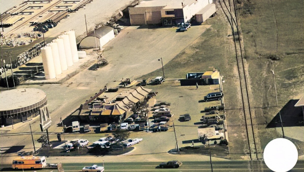
From 1978. I believe this spot has been show before. The main difference is that now the tracks end short of the main road but are still in use.
Re: Where Is It?
Is the track in the picture still in place or is it the bottom (out of picture) that’s still in place?
PatC created a monster, 'cause nobody wants to see Don Simon no more they want AARR I'm chopped liver, well if you want AARR this is what I'll give ya, bad humor mixed with irrelevant info that'll make you roll your eyes quicker than a ~Z~ banhammer...
-
railrod1949
- Railroadfan...fan
- Posts: 1317
- Joined: Mon Oct 26, 2015 8:19 am
- Location: Waterford, MI
Re: Where Is It?
-
Michael
- Railroadfan...fan
- Posts: 10893
- Joined: Sun Sep 12, 2010 2:52 pm
- Location: Plymouth, Michigan
Re: Where Is It?
It is NOT SEM.
Sorry, AARR I did not explain that well. Yes almost all the track in the photo is still in place but it ends about where the white truck is.
Sorry, AARR I did not explain that well. Yes almost all the track in the photo is still in place but it ends about where the white truck is.
-
railrod1949
- Railroadfan...fan
- Posts: 1317
- Joined: Mon Oct 26, 2015 8:19 am
- Location: Waterford, MI
Re: Where Is It?
Is it in the Kalamazoo area?
PatC created a monster, 'cause nobody wants to see Don Simon no more they want AARR I'm chopped liver, well if you want AARR this is what I'll give ya, bad humor mixed with irrelevant info that'll make you roll your eyes quicker than a ~Z~ banhammer...
-
DaveO
- Read more, think more, post less
- Posts: 1465
- Joined: Thu Dec 14, 2017 12:57 pm
- Location: Between here and there
Re: Where Is It?
Let's see:
Not in SEM.
McDonalds not there. In that time frame they only closed stores to relocate them nearby.
Leaves on trees. Summer.
McD's parking lot full, must be noon. With that sun angle, the road runs north-south.
Track now ends east side of road.
Looks like a fuel-oil depot behind McD's.
Next to that is an electric utility pole/supply yard.
Roadway appears to be 4 lanes. Good chance it's a state highway.
The above tends to support it's close to decent sized town.
Where? I have no idea.
But it will be interesting to see how close I was to reading clues.