Page 1 of 1
Whose Pilings are These?
Posted: Tue Sep 19, 2017 8:32 pm
by SteveHiuzenga
We have friends that have a cottage on the Betsie River, just southwest of Thompsonville. These pilings are right in front of their cabin, their driveway is the old railroad grade to these pilings....the road on the other side of the river is called 'Old Grade Road'. So whose are they? Bear Lake and Eastern perhaps?
Re: Whose Pilings are These?
Posted: Wed Sep 20, 2017 10:58 am
by James Sofonia
Well pilings look a little too wide in the picture to have been part of a RR trestle. Maybe some other structure. At first I thought the Manistee and Northeastern RR as it ran thru the area. But the pilings look too old for that line as it was around till about 1931 in that area. So maybe if it is a RR your guess of the Bear Lake and Eastern may be correct as it was abandoned in 1902.
Re: Whose Pilings are These?
Posted: Wed Sep 20, 2017 10:20 pm
by SteveHiuzenga
I thought they looked a tad wide as well...but there was a railroad through there...as i said, "Old grade road" is on the other side...complete with old crossbucks...and also on this side of the river is the same sign, even though the road on Google maps has a different name Holly drive)
Attached are photos of the area...the close up has the pilings circled...when the map was shot there was a lot of debris built up around the pilings, but as you can see in my original photo, that debris has been removed.
Re: Whose Pilings are These?
Posted: Thu Sep 21, 2017 10:04 am
by James Sofonia
I found this photo posted by Don Harrison of a bridge on the NW MI Bear Lake & Eastern Railroad near Springdale Henry Copmish and Arcadia & Betsey River Railway. Perhaps this is your bridge or one like it in the area. If so this would explain the wide stance of the pilings.
Re: Whose Pilings are These?
Posted: Thu Sep 21, 2017 11:16 am
by aghudley
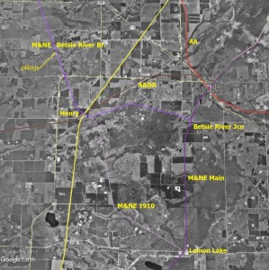
The pilings are from the M&NE Betsie River Branch, constructed in 1900-01 from Betsie River Jcn, SW of Copemish, through Henry to section 19 or 20 (depending on the source) of Weldon Township, Benzie County. The branch was taken up in 1904. The attached map shows my hen scratchings of the area around Henry. Click on the image to see it more clearly.

- Area around Henry, MI
I forgot a label. The yellow line is PM.
I had an interesting conversation last year with Mr. Meints, Mr. Hannum and Mr. Henry Burger about this area. My information comes from that conversation and from the sources below. The M&NE line shown from Lemon Lake to Henry was likely constructed after the original Betsie River Branch, but no documentation of when and why has turned up. It is shown on a 1910 M&NE blue print shared by Mr. Hannum but not on an 1899 engineering drawing shared by Mr. Burger.
Michigan Railroad Lines, Vol 1, Graydon M. Meints, (c) 2005, Michigan State University Press
Michigan Railroad Atlas, Vol 1 & 3, Graydon M. Meints, (c) 2017, Michigan State University Press
In the Pines - An Atlas of Michigan Logging Railroads, James S. Hannum, M.D., (c) 2017 Hannum House Press
The Meints books are available from Amazon.
The Hannum book will be available for reference from several northern Michigan libraries and historical museums and will be available for purchase
only once, this Saturday (9-23-17) at the Michigan Railroad Historical Conference at Hope College in Holland. See you there.
Re: Whose Pilings are These?
Posted: Fri Sep 22, 2017 7:48 pm
by M.D.Bentley
My grand pa has piles..............................
Re: Whose Pilings are These?
Posted: Fri Sep 22, 2017 11:15 pm
by hoborich
That was the polite name for them.

Re: Whose Pilings are These?
Posted: Sat Sep 23, 2017 9:45 am
by ~Z~
Nice research and historical info; thanks guys.
Re: Whose Pilings are These?
Posted: Mon Sep 25, 2017 6:50 am
by SteveHiuzenga
i agree....thanks so much...makes sense now too, cause the place was build right around the time the line would have been torn up.
Re: Whose Pilings are These?
Posted: Thu Sep 28, 2017 9:44 pm
by MQT1223
SteveHiuzenga wrote:I thought they looked a tad wide as well...but there was a railroad through there...as i said, "Old grade road" is on the other side...complete with old crossbucks...and also on this side of the river is the same sign, even though the road on Google maps has a different name Holly drive)
Attached are photos of the area...the close up has the pilings circled...when the map was shot there was a lot of debris built up around the pilings, but as you can see in my original photo, that debris has been removed.
close up.JPG
map.JPG
Any pics of the crossbucks? The old ones are always of interest. The M&NE had a style unique to them and I've only seen pics of them.