Drove my car right to the fence. Plenty of people saw me and didn't seem to mind. Only thing that is left is the concrete approaches. Were you aware of the bridge remnants near the bridge by Roosevelt Park? All that is left of that is the approaches too.J T wrote:Mystery solved. Did you ride your bike back there through the scrapper lot?MQT1223 wrote:There is no bridge intact near the scrapper although rails are intact across the entire property.
Another from the "WAI" thread...
-
MQT1223
- O Scale Railfanner
- Posts: 4069
- Joined: Wed Sep 10, 2014 1:46 pm
- Location: Grandville, Michigan
- Contact:
Re: Another from the "WAI" thread...
1223 OUT! President and Founder of the Buck Creek Central, the Rolling River Route! (2012-2017) President and Founder of the Lamberton Valley Railroad, The Tin Plate Road! Proudly railfanning with Asperger's since 1996. 
-
Saturnalia
- Authority on Cat
- Posts: 15393
- Joined: Wed Sep 28, 2011 7:54 pm
- Location: Michigan City, IN
- Contact:
Re: Another from the "WAI" thread...
Gonna suspect that they were steel bridges, and being small and accessible, were taken for scrap or resale and reuse.MQT1223 wrote:Drove my car right to the fence. Plenty of people saw me and didn't seem to mind. Only thing that is left is the concrete approaches. Were you aware of the bridge remnants near the bridge by Roosevelt Park? All that is left of that is the approaches too.J T wrote:Mystery solved. Did you ride your bike back there through the scrapper lot?MQT1223 wrote:There is no bridge intact near the scrapper although rails are intact across the entire property.
I'm surprised how often railroads, especially the interurbans, used bridges second-hand. I guess it was cheaper to buy one disassembled from older railroads who'd outgrown them then to buy new and assemble on site. The GR, GH & M had at least one if not two examples of this.
-
MQT1223
- O Scale Railfanner
- Posts: 4069
- Joined: Wed Sep 10, 2014 1:46 pm
- Location: Grandville, Michigan
- Contact:
Re: Another from the "WAI" thread...
Wouldn't surprise me as light as the interurban cars were. The load might be too heavy for a steam locomotive or diesel but not for a lightweight street car.MQT3001 wrote:MQT1223 wrote:Gonna suspect that they were steel bridges, and being small and accessible, were taken for scrap or resale and reuse.J T wrote:
Drove my car right to the fence. Plenty of people saw me and didn't seem to mind. Only thing that is left is the concrete approaches. Were you aware of the bridge remnants near the bridge by Roosevelt Park? All that is left of that is the approaches too.
I'm surprised how often railroads, especially the interurbans, used bridges second-hand. I guess it was cheaper to buy one disassembled from older railroads who'd outgrown them then to buy new and assemble on site. The GR, GH & M had at least one if not two examples of this.
1223 OUT! President and Founder of the Buck Creek Central, the Rolling River Route! (2012-2017) President and Founder of the Lamberton Valley Railroad, The Tin Plate Road! Proudly railfanning with Asperger's since 1996.
-
Ben Higdon

- Railroadfan...fan
- Posts: 844
- Joined: Wed Jan 25, 2006 2:02 pm
Re: Another from the "WAI" thread...
Street cars and interurbans are completely different things.
Re: Another from the "WAI" thread...
Gonna add a new one to this...
This picture is the 8 Mile Road bridge southeast of South Lyon, and because of the wide piers and retaining walls, I was wondering if there was ever double-track or something like that located here in the past. Anyone know anything about this?
Link to photo: download/file.php?id=582&mode=view
This picture is the 8 Mile Road bridge southeast of South Lyon, and because of the wide piers and retaining walls, I was wondering if there was ever double-track or something like that located here in the past. Anyone know anything about this?
Link to photo: download/file.php?id=582&mode=view
-
Saturnalia
- Authority on Cat
- Posts: 15393
- Joined: Wed Sep 28, 2011 7:54 pm
- Location: Michigan City, IN
- Contact:
Re: Another from the "WAI" thread...
Never had double-track. Probably built with the idea that one could be added in the future. Not really uncommon.59caddy wrote:Gonna add a new one to this...
This picture is the 8 Mile Road bridge southeast of South Lyon, and because of the wide piers and retaining walls, I was wondering if there was ever double-track or something like that located here in the past. Anyone know anything about this?
Link to photo: download/file.php?id=582&mode=view
Re: Another from the "WAI" thread...
That would make sense, because I was wondering why the bridge looked so old.MQT3001 wrote:Never had double-track. Probably built with the idea that one could be added in the future. Not really uncommon.59caddy wrote:Gonna add a new one to this...
This picture is the 8 Mile Road bridge southeast of South Lyon, and because of the wide piers and retaining walls, I was wondering if there was ever double-track or something like that located here in the past. Anyone know anything about this?
Link to photo: download/file.php?id=582&mode=view
-
Ben Higdon
- Railroadfan...fan
- Posts: 844
- Joined: Wed Jan 25, 2006 2:02 pm
Re: Another from the "WAI" thread...
This map requires some serious zooming in to see anything, but its got some interesting info. Its dated 1925. A gent at the Grand Rapids public library was kind enough to take a picture of it and email it to me.
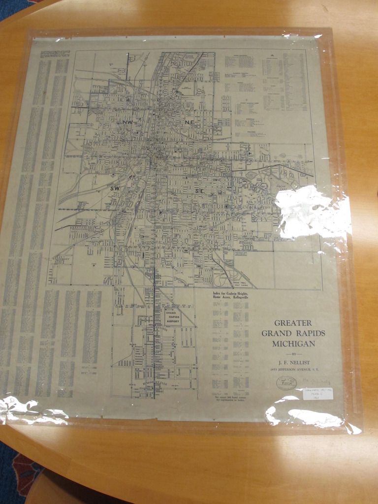
Interesting to note the interurban line from Kalamazoo crosses the PRR farther south...can't really tell if there was a fly-over or a crossing at grade. Topographic maps appear to show a distinctive outline of a earthen approach for a flyover just south of Burton, perhaps they replaced the crossing at grade shown on this map at a later date with the flyover near Burton?
The valley that the interurban and PRR Plaster Mill Track passed through is called "Pleasant Valley".
The east leg of the wye at Sunnyside looks like it only connects to the lead to Union Station, rather than the main line. Makes sense but something I hadn't been aware of.
Anyone know which line reached Sunnyside first, GR&I or the PM predecessor? I've never seen a map showing the lines cross there, did they always cross each other via crossovers?
-
Saturnalia
- Authority on Cat
- Posts: 15393
- Joined: Wed Sep 28, 2011 7:54 pm
- Location: Michigan City, IN
- Contact:
Re: Another from the "WAI" thread...
Well, there were two PM Predessors. The Detroit, Grand Rapids & Western came in from Detroit and up by Pleasant St to Union Station (they were the last RR to build into GR except interurbans).
Opposite, the Chicago & West Michigan came in from Porter, past Sunnyside and curved up to Union Station. Originally, they were not connected like they are now, at least AFAIK.
I'm assuming around the time of the merger, they built the current alignment, with the Detroit line curving sharply over the GR&I/US leads to meet the CWM at the present location of the Sunnyside Wye. This is a reason for all the whack curvature down there now.
Interestingly, the mileposts patch up exactly. The DGRW tapes to Godfrey (re-lined instead of going to Union Station) to 151.7. Meanwhile, the CWM, measuring from Union Station, was at 0.7 at Godfrey.
Does that make sense?

Re: Another from the "WAI" thread...
The bridge abutments for the GRE over the Grand River are set up for a second bridge.MQT3001 wrote:Never had double-track. Probably built with the idea that one could be added in the future. Not really uncommon.59caddy wrote:Gonna add a new one to this...
This picture is the 8 Mile Road bridge southeast of South Lyon, and because of the wide piers and retaining walls, I was wondering if there was ever double-track or something like that located here in the past. Anyone know anything about this?
Link to photo: download/file.php?id=582&mode=view
https://www.flickr.com/photos/jimthias/
GRHC - you know every night I can imagine he is in front of his computer screen sitting in his underwear swearing profusely and drinking Blatz beer combing the RailRoadFan website for grammatical errors.
GRHC - you know every night I can imagine he is in front of his computer screen sitting in his underwear swearing profusely and drinking Blatz beer combing the RailRoadFan website for grammatical errors.
-
Doktor No

- Railroadfan...fan
- Posts: 1078
- Joined: Wed Feb 04, 2015 4:49 pm
- Location: Rockford, Michigan
Re: Another from the "WAI" thread...
That stretch of the PRR you all are talking about was always called the PK Industrial. Jack Smith stories in the PRRT&HS Magazine talked about this at one time or another. There is a lot of info in the PRR society magazine and if you go to their website they may just have those mags still in stock. Dieselizing the Grand Rapids Division is one story. Another covered the Muskegon Branch operations. Good pics of the jct at Walker. They even had a tower there at one time! ANother good story is the one by Charles Galetzke, How We Do Things On The PRR, story of a GTW trip with a newbie from Durand to Muskegon and back in the late 60's.
As for the interurban crossing the PRR, it was done on a large steel bridge built right at the beginning of the operations and used till the end.
Now should you all be so interested go dig up some plat maps of the area in Kentwood or what was then Paris Twp from the NYC line to Jackson at 52nd Street. Follow what now is a Consumers power line with towers westward to Division Ave...just to the north of 52nd Street just south of 48th. You will see the right of way is owned by the NYC from their line to Division Ave between 50th and 52nd. They owned the corner of 52nd and Eastern at one time...they still show ownership into the late 50's early 60's on the plat maps. All available online to boot. I never saw a tie in to the interurban line though and that would have been half a block west of Division. Maps of the 50's still showed interurban rail intact up to 50th Street but my mom moved to Urban Street between 50th and Holly and said there was never rail left across the street from our house when they moved in in 1948 or so. We used to find spikes and tie plates when we were kids, back in the 60's.
Anytime anyone wants to take a tour lemme know. Been there, lived it. Leave a message.
Curb Your Enthusiasm.