Page 5 of 6
Re: LS&MS Grand Rapids Division Pics
Posted: Mon Feb 23, 2015 9:15 pm
by Ben Higdon
J T wrote:It appears that Wentworth was there in in this 1912 map as well:
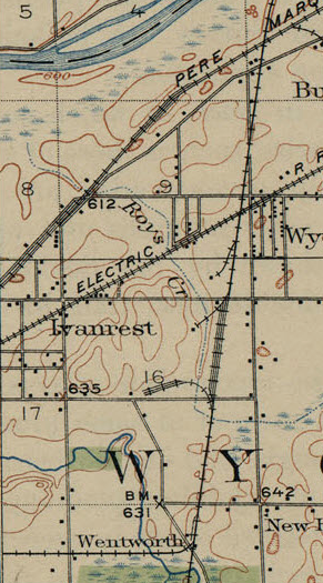
Cool map
Re: LS&MS Grand Rapids Division Pics
Posted: Sat Feb 28, 2015 3:51 pm
by MQT1223
Just somthing. I thought I should add. Between 28th and Porter is a street called Thornwood. If you go down Thornwood you will go over a very noticable intact section of this LS&MS grade. Even both stopsigns are still standing as if the crossbucks were still there and the pavement looks like the rails were only recently rememoved. I'm guessing the section south of Lamar was in service longer then the rest to serve some industries.
Re: LS&MS Grand Rapids Division Pics
Posted: Sat Feb 28, 2015 3:53 pm
by Saturnalia
Did CSX or predessor ever operate in that line south of Lamar, even f just a short time?
Re: LS&MS Grand Rapids Division Pics
Posted: Sat Feb 28, 2015 5:50 pm
by MQT1223
MQT3001 wrote:Did CSX or predessor ever operate in that line south of Lamar, even f just a short time?
That's what I'm wondering too.
Re: LS&MS Grand Rapids Division Pics
Posted: Sat Feb 28, 2015 7:09 pm
by Doktor No
If I remember correctly we served the lumber yard from time to time just across the street from the Legion Hall. Burlingame WIndow??? I remember a BCOL bulkhead flat back there long after the diamonds were gone and during my C&O tenure.
Re: LS&MS Grand Rapids Division Pics
Posted: Sat Feb 28, 2015 7:20 pm
by kenN
By the time I started working in the area in the mid-'80s, the line was severed, but rails were still in place in the Byron Center Ave crossing, and also at Thornwood, as mentioned. A small stub of the interchange track was in place that CSX used to spot an occasional car of wood chips for Brinks, also to store MOW equipment.
Re: LS&MS Grand Rapids Division Pics
Posted: Sat Feb 28, 2015 9:12 pm
by MQT1223
KittyLitter wrote:If I remember correctly we served the lumber yard from time to time just across the street from the Legion Hall. Burlingame WIndow??? I remember a BCOL bulkhead flat back there long after the diamonds were gone and during my C&O tenure.
So I'm guessing this was all north of 28th street but south of the River? C&O for a brief time served that portion of the line?
kenN wrote:By the time I started working in the area in the mid-'80s, the line was severed, but rails were still in place in the Byron Center Ave crossing, and also at Thornwood, as mentioned. A small stub of the interchange track was in place that CSX used to spot an occasional car of wood chips for Brinks, also to store MOW equipment.
That must've been a large crossing considering the angle of which the rails would've intersected the road. Was Lamar Park in yet? Did the rails go above the park on the embankment behind all the buildings between Byron Center and Porter or on the eastern edge where they now mow the grass in the park?
Re: LS&MS Grand Rapids Division Pics
Posted: Sat Feb 28, 2015 11:35 pm
by kenN
Yes, the tracks crossed at a very sharp angle to the road (I think there's still a small jog in the road there); the ROW south of that crossing bordered Lamar Park, up on the bank just west of the buildings. By that time, the rails south of the ex-diamond were gone; Chicago Drive showed no sign there ever was a crossing there.
Re: LS&MS Grand Rapids Division Pics
Posted: Sun Mar 01, 2015 12:41 am
by MQT1223
kenN wrote:Yes, the tracks crossed at a very sharp angle to the road (I think there's still a small jog in the road there); the ROW south of that crossing bordered Lamar Park, up on the bank just west of the buildings. By that time, the rails south of the ex-diamond were gone; Chicago Drive showed no sign there ever was a crossing there.
I see. But at one point it sounds as if there was a large enough customer base to keep a small section of line in business south of Lamar, unless the PC was the last railroad to serve those industries. It kind of stinks it couldn't happen again, Thornwood still has a lot of industry that is served by trucks now. Kent Door at 28th St. still has doors on the east side of the building for boxcars to be unloaded. The area on the east side of the building is not big enough for a big rig. The whole setup is kind of similar to the other spur in the area (name escapes me). It just amazes me that even to this day that the stop signs are still in place on Thornwood, BOTH of them. Makes me wonder if anyone bothers to stop for them anymore. I stop to look down both ways of the overgrown ROW. Would a cop pull you over for blowing a pointless stop sign?
Re: LS&MS Grand Rapids Division Pics
Posted: Sun Mar 01, 2015 7:53 am
by J T
They are saving the stop signs for when they put the tracks back in.
Re: LS&MS Grand Rapids Division Pics
Posted: Sun Mar 01, 2015 11:44 am
by wyrickj
So those stop signs on Thornwood were from PC days or possibly even from NYC days? I've been on that row all the way to the interurban crossing looks nothing like the old pictures though.
Re: LS&MS Grand Rapids Division Pics
Posted: Sun Mar 01, 2015 12:16 pm
by MQT1223
wyrickj wrote:So those stop signs on Thornwood were from PC days or possibly even from NYC days? I've been on that row all the way to the interurban crossing looks nothing like the old pictures though.
Yeah the old pictures at the Interurban slide show were drastically different. Its amazing what time can do to one location. The Interurban crossing was in a field, and I'm sure most of the ROW went through farmland originally. Its all been developed and what wasn't got grown up with trees. I don't know if the stop signs are that old, they look to be newer. If I knew how to post pictures from my phone I would go down there and post a pic of the "crossing"
Re: LS&MS Grand Rapids Division Pics
Posted: Mon Mar 02, 2015 6:33 pm
by J T
I drove down Thornwood yesterday to look at those stop signs at the old grade crossing. Just beyond the stop sign while heading west is a sign that announces it to be a private road. My initial impression was the stop sign was there to keep people from just cruising right along into that private area. I'm suspecting that is what it's for and the private property line just happens to be at the old grade crossing. On the return back to Thornwood, the stop sign for eastbound traffic is a little perplexing. There is also a sign just beyond it announcing that you are entering a residential street (or something to that effect). However, if you've already driven into the private area (which appears to be accessible only from Thornwood), you'd already know that you are entering a residential street and probably wouldn't have any reason to stop.
Just my speculation, so take it with a grain of salt.

Re: LS&MS Grand Rapids Division Pics
Posted: Mon Mar 02, 2015 9:08 pm
by MQT1223
J T wrote:I drove down Thornwood yesterday to look at those stop signs at the old grade crossing. Just beyond the stop sign while heading west is a sign that announces it to be a private road. My initial impression was the stop sign was there to keep people from just cruising right along into that private area. I'm suspecting that is what it's for and the private property line just happens to be at the old grade crossing. On the return back to Thornwood, the stop sign for eastbound traffic is a little perplexing. There is also a sign just beyond it announcing that you are entering a residential street (or something to that effect). However, if you've already driven into the private area (which appears to be accessible only from Thornwood), you'd already know that you are entering a residential street and probably wouldn't have any reason to stop.
Just my speculation, so take it with a grain of salt.
It is very perplexing. It could be for the private street, but I think it is left in from the original crossing. Cause why is it on both sides of the roadbed and not ON the roadbed. You get what I mean? Plus when you drive over the spot where the rails were it lines up exactly with the patch in the road.
Re: LS&MS Grand Rapids Division Pics
Posted: Fri Mar 06, 2015 6:05 pm
by MQT1223
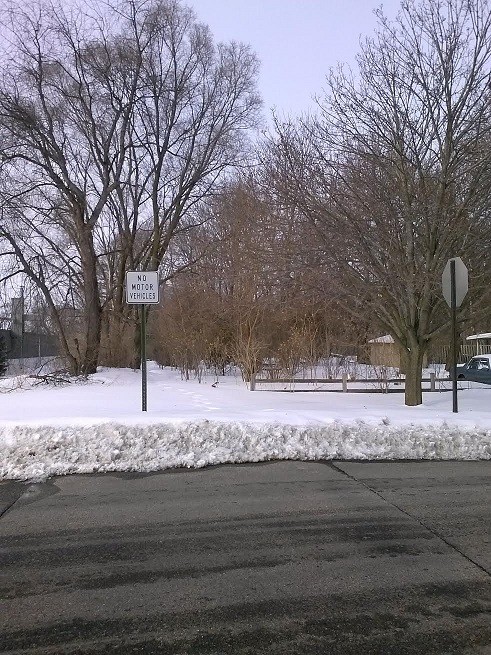
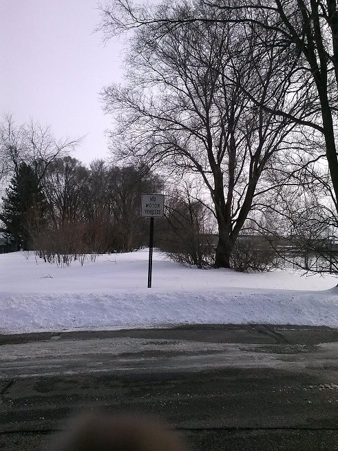
Here are pictures of the "crossing" on Thornwood. Take them as you might as to why the stop signs are STILL here.
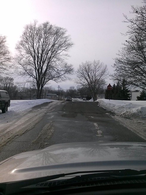
Looking west over the crossing. Note the very visible grade leading up to the ROW on this side and the stop signs.
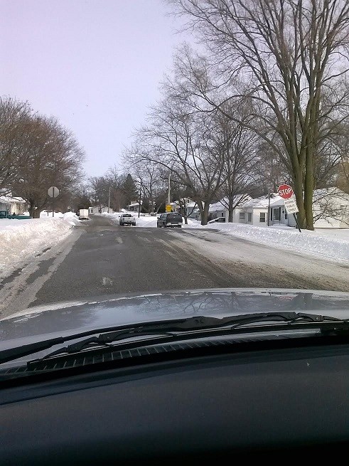
Looking east over the crossing. The grade is not as pronounced on this side but the stop signs are easier to see.
Looking northbound on the LS&MS. Turn back the clock 100 years and this would've been a wide open field and you could see as far down as to the diamonds at Lamar and the catenary wires of the Grand Rapids, Holland and Chicago. It is still very clear in the pavement where the rails once were. The stop sign still stands guard for the ghosts of the LS&MS/NYC.
Looking southbound on the LS&MS. The patch in the road is still easy to pick out even with the ice and slush. 28th street is roughly a mile away and traffic could be seen if the brush was cleared. The ROW crossed there to the right of the Kent Door factory. On the south side of 28th street the ROW is now a road next to a mulch business. The only way to follow the ROW between there and Prairie is on Google Maps or MapQuest as it has been heavily developed. A stop sign is just out of view here, and a tree is slowly pushing it towards the road. The houses must've been built here when the line was nearly dead, as most of them are built close to the ROW.
I would not be surprised if the homeowners along this stretch of abandoned ROW have no idea of what used to sit here. If you want to walk this ROW (I have walked and biked it several times) start from down at Porter St. where the "NO MOTOR VEHICLES" sign is and walk south. From there you will go under twin power lines, which is the location of the former trestle/diamonds of the Grand Rapids, Holland and Chicago. After that you will walk between the houses of people that live on Byron Center Ave. and the large businesses that get access from Thornwood Ave. After you cross Thornwood you will enter a large area of grass next to a private school and unless you walk next to the Kent Door Factory at 28th street the ROW is basically invisible. At the door factory loading docks still exist on the side of the building for unloading boxcars and other rolling stock. The area with the loading docks could only fit a small truck today, but larger loading docks on the front of the building are used instead. This area is usually full of tall weeds in the summer. I recommend walking this ROW in the spring when the bugs aren't bad and the wild apple and cherry trees that have sprung up along the ROW are in full bloom. It gets quite nice back there around that time.
Re: LS&MS Grand Rapids Division Pics
Posted: Fri Mar 06, 2015 7:35 pm
by Raildudes dad
Those stop signs my friends are totally unwarranted and need to come down. One should say "end pubic street" (WB) and the other "begin public street"(EB)
Re: LS&MS Grand Rapids Division Pics
Posted: Fri Mar 06, 2015 7:58 pm
by MQT1223
Raildudes dad wrote:Those stop signs my friends are totally unwarranted and need to come down. One should say "end pubic street" (WB) and the other "begin public street"(EB)
There is a sign beyond the westbound sign that says "entering private road", I just didn't capture it in the photo. I was in my car and took these with my cell phone. If you look at the second picture the leaning stop sign has "entering public road" underneath it. A UPS truck actually came to a full stop for about 5 seconds at the eastbound sign when I was there taking these and looked both ways. One they stopped for the stop sign, that's impressive in its own right, two they LOOKED BOTH WAYS... what were they looking for?

Re: LS&MS Grand Rapids Division Pics
Posted: Fri Mar 06, 2015 8:30 pm
by J T
MQT1223 wrote:
28th street is roughly a mile away and traffic could be seen if the brush was cleared.
Actually, 28th Street is only 1/4 mile to the south of Thornwood, but that's neither here nor there.
Re: LS&MS Grand Rapids Division Pics
Posted: Fri Mar 06, 2015 9:38 pm
by MQT1223
J T wrote:MQT1223 wrote:
28th street is roughly a mile away and traffic could be seen if the brush was cleared.
Actually, 28th Street is only 1/4 mile to the south of Thornwood, but that's neither here nor there.
I'm not good with distances if you can tell J T.
Re: LS&MS Grand Rapids Division Pics
Posted: Tue Mar 10, 2015 2:04 pm
by J T
KittyLitter wrote:
As for the diamond being an operating headache with a MAINLINE crossing our line? It was at best an industrial lead with infrequent movements.
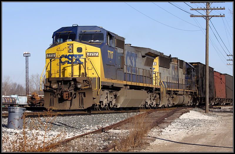
Looking through some old pics, I forgot I had one showing that lead...