I have started a photo gallery of aerial photos of the Grand Rapids area. I have access at work to aerial photos of Kent County from 1938, 1954, 1963, 1978 and 1984. These prints were / are used stereoscopically by our engineers to delineate drainage areas for culvert and storm sewer design. Dick DV was interested in the area around Union Station before the freeway went in so I posted a 1954 and 1963 photo of downtown for comparison. I also posted photos of the Hughart yard area before and after the freeway. Paul D was interested in the GTW along Monroe from Bridge Street to Leonard Street so I posted a photo of that area.
If there are other areas that you would like to see, make a request and I’ll see what I can do. Thanks to Pianoman for converting my tif files to png files so the photos could be easily viewed.
Along somewhat of a related topic, I was cleaning files at work this week. In the back of a little used drawer in our permanent files, I found a file on a proposed Wealthy Street viaduct from 1930. Why it was in our files since it was in the city, I do not know. The viaduct was proposed due to the congestion caused by the 15 to 20 tracks crossing the streets south of Union Station and the various PM, GR&I, and MC freight houses. Included in the file was a 1929 track diagram from south of Franklin Street north to Fulton. I will try to scan it as well and post it for your viewing pleasure. Also in the file is a 1929 map of Grand Rapids that has all the railroads on it. I’ll try to get it posted as well.
Grand Rapids Aerial Photos
-
Raildudes dad
- Roadmaster
- Posts: 4753
- Joined: Fri Dec 23, 2005 9:12 am
- Location: Grand Rapids, MI
-
~Z~

- Sofa King Admin
- Posts: 12941
- Joined: Tue Oct 12, 2004 2:14 pm
- Location: Grand Rapids, MI
- Contact:
Here's a link to his photo gallery:
http://www.railroadfan.com/gallery/thum ... ?album=243
http://www.railroadfan.com/gallery/thum ... ?album=243
Webmaster
Railroad photos on Railroadfan.com
Railroad photos on Railroadfan.com
-
i995impalass
- Yooper Foamer
- Posts: 1527
- Joined: Wed Aug 30, 2006 12:00 am
- Location: Marquette, MI
-
Raildudes dad
- Roadmaster
- Posts: 4753
- Joined: Fri Dec 23, 2005 9:12 am
- Location: Grand Rapids, MI
-
i995impalass
- Yooper Foamer
- Posts: 1527
- Joined: Wed Aug 30, 2006 12:00 am
- Location: Marquette, MI
Dang not so clears, oh well umm if you have the Conrail yard north, or the Wyoming Yard, i guess kinda in the area that the others where in. Do you also know when the double main on the old GTW just east of the Fuller Jct to Highland Park was taken out? Passing over it on 131 you can see the piers held a double track over the Grand and also on the bridge over Monroe plus all the siding that you see on the strech. ~Thanks Chris
-
Raildudes dad
- Roadmaster
- Posts: 4753
- Joined: Fri Dec 23, 2005 9:12 am
- Location: Grand Rapids, MI
-
i995impalass
- Yooper Foamer
- Posts: 1527
- Joined: Wed Aug 30, 2006 12:00 am
- Location: Marquette, MI
-
i995impalass
- Yooper Foamer
- Posts: 1527
- Joined: Wed Aug 30, 2006 12:00 am
- Location: Marquette, MI

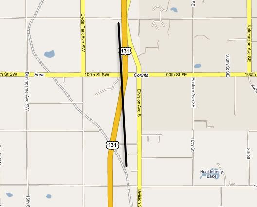
Any chance for aerial photos south of GR down near 100th St? There is a stretch of land along the highway that I'm curious about. Just north of 100th St, along the west side of the highway is an old graded road that looks like a railroad grade. The reason I think it MIGHT be an old railroad grade is because it cuts through the small hills and there's also an old stone bridge structure over a creek. Looks like it might have been built as far back as the 1800's. If you follow where the grade went to the south, it lines up almost perfectly with where the NS line is back on the east side of the highway, which to me looks like it may have been a spur at one time, LONG before 131 was built.
Has anyone else ever noticed this? I can't imagine ANYONE would cut into the smalls hills for regular vehicle traffic (old cars and tractors).
Has anyone else ever noticed this? I can't imagine ANYONE would cut into the smalls hills for regular vehicle traffic (old cars and tractors).
-
Raildudes dad
- Roadmaster
- Posts: 4753
- Joined: Fri Dec 23, 2005 9:12 am
- Location: Grand Rapids, MI
The grade along US 131 south of GR is the Michigan Electric Railway interurban roadbed. Built in the early 20's done by the late 20's. You can follow the grade just about everywhere between dowentown GR and downtown Kazoo. You'll notice today it is home to electric transmission lines. 
Regarding posting more areas, I have access to photos from 1938, 1954, 1963, 1978 and 1984. Tell me the area & date and I'll see what I can do.
Regarding posting more areas, I have access to photos from 1938, 1954, 1963, 1978 and 1984. Tell me the area & date and I'll see what I can do.
Ok, I thought it might have been an old spur because it stops cold about a mile north of 100th ave (at 92nd ave, I think), and south of 100th the bed continues in a straight line heading toward the existing NS line. Beyond the north end, there are hilly fields with NO trace whatsoever of an old RR bed.Raildudes dad wrote:The grade along US 131 south of GR is the Michigan Electric Railway interurban roadbed. Built in the early 20's done by the late 20's. You can follow the grade just about everywhere between dowentown GR and downtown Kazoo. You'll notice today it is home to electric transmission lines.
Regarding posting more areas, I have access to photos from 1938, 1954, 1963, 1978 and 1984. Tell me the area & date and I'll see what I can do.
You're right about the power lines. South of 100th the bed has power lines on it.
The black line is the old bed:
-
Raildudes dad
- Roadmaster
- Posts: 4753
- Joined: Fri Dec 23, 2005 9:12 am
- Location: Grand Rapids, MI
Going north of 92nd street, the trackbed goes to the east a little. At 84th Street it is east of the new Road Commission building and MI Cat - again look for the power lines. You can follow them all the way to downtown GR  Consumers Power bought the ROW from Michigan Electric Railway went it went bankrupt. There's a lot of info out there on the interurban.
-
Raildudes dad
- Roadmaster
- Posts: 4753
- Joined: Fri Dec 23, 2005 9:12 am
- Location: Grand Rapids, MI
-
SD80MAC
- Ingersoll's Mr. Michigan
- Posts: 10464
- Joined: Thu Mar 10, 2005 4:59 pm
- Location: Grand Rapids
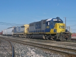
Raildudes dad, any more recent pics of Wyoming and Hugart yards?
"Remember, 4 mph is a couple, 5's a collision!"
http://flickriver.com/photos/conrail680 ... teresting/
http://flickriver.com/photos/conrail680 ... teresting/
-
Raildudes dad
- Roadmaster
- Posts: 4753
- Joined: Fri Dec 23, 2005 9:12 am
- Location: Grand Rapids, MI
The "newest" aerial photos we have are 1984. The most recent photos taken are available are on line at http://ims.gvmc-regis.org/website/publi ... arcel_Find
You need to be patient, the program is sllooowww
You need to be patient, the program is sllooowww
-
i995impalass
- Yooper Foamer
- Posts: 1527
- Joined: Wed Aug 30, 2006 12:00 am
- Location: Marquette, MI
I thought that was the old GR&I GradeRaildudes dad wrote:The grade along US 131 south of GR is the Michigan Electric Railway interurban roadbed. Built in the early 20's done by the late 20's. You can follow the grade just about everywhere between dowentown GR and downtown Kazoo. You'll notice today it is home to electric transmission lines.
Regarding posting more areas, I have access to photos from 1938, 1954, 1963, 1978 and 1984. Tell me the area & date and I'll see what I can do.
-
Raildudes dad
- Roadmaster
- Posts: 4753
- Joined: Fri Dec 23, 2005 9:12 am
- Location: Grand Rapids, MI
-
i995impalass
- Yooper Foamer
- Posts: 1527
- Joined: Wed Aug 30, 2006 12:00 am
- Location: Marquette, MI