Page 384 of 560
Re: Where Is It?
Posted: Wed Jun 06, 2018 9:32 am
by ConrailDetroit
Re: Where Is It?
Posted: Wed Jun 06, 2018 10:13 am
by James Sofonia
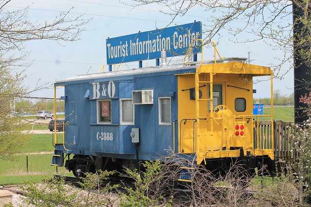
Near intersection of Hy. 309 and I-75, Lima Ohio.
Re: Where Is It?
Posted: Wed Jun 06, 2018 10:15 am
by ~Z~
Pixl wrote:
Near intersection of Hy. 309 and I-75, Lima Ohio.
I can confirm Pixl's findings, was typing almost the same. Tourist Information Center used by Lima Allen County Convention & Vistors Bureau in Lima.
Re: Where Is It?
Posted: Wed Jun 06, 2018 11:38 am
by ConrailDetroit
Correct
Re: Where Is It?
Posted: Wed Jun 06, 2018 12:22 pm
by James Sofonia
ConrailDetroit wrote:Correct
Good shot Conrail. You can just barely see it on Google Street View.
Re: Where Is It?
Posted: Wed Jun 06, 2018 12:27 pm
by railrod1949
~Z~ wrote:Pixl wrote:
Near intersection of Hy. 309 and I-75, Lima Ohio.
I can confirm Pixl's findings, was typing almost the same. Tourist Information Center used by Lima Allen County Convention & Vistors Bureau in Lima.
Yes, indeed, it'a the Blue Caboose used by the Lima Allen County Convention and Tourist center ia open only during the summer months from memorial Day to Labor Day. Its located on the west side of Roschman Avenue at the southwest corner of the Howard Johnson hotel parking lot in the southeast corner of I-75 and Ohio Highway 309. It is between Cracker Barrell restaurant and the Howard Johnson Hotel. All near Lima, OH, Allen County, OH.
Re: Where Is It?
Posted: Wed Jun 06, 2018 1:35 pm
by James Sofonia
Well I did much research on this location, but could not confirm all facts. But that said, I believe the state highway in front of this restaurant under the pavement used to be a branch line of a major RR in the area.
Re: Where Is It?
Posted: Wed Jun 06, 2018 5:02 pm
by ~Z~
Pixl wrote:Well I did much research on this location, but could not confirm all facts. But that said, I believe the state highway in front of this restaurant under the pavement used to be a branch line of a major RR in the area.
Henry's Hamburgers in Benton Harbor on M-139?
Hopefully that's it.. man, google is useful. Went to image search, typed in "green red hamburgers sign michigan" and was the sign out front was on the first page of results

Re: Where Is It?
Posted: Wed Jun 06, 2018 7:14 pm
by DaveO
Pixl wrote:Well I did much research on this location, but could not confirm all facts. But that said, I believe the state highway in front of this restaurant under the pavement used to be a branch line of a major RR in the area.
It was a Pere Marquette line. It seems that road is built on the r-o-w there.
Re: Where Is It?
Posted: Wed Jun 06, 2018 7:31 pm
by railrod1949
DaveO wrote:Pixl wrote:Well I did much research on this location, but could not confirm all facts. But that said, I believe the state highway in front of this restaurant under the pavement used to be a branch line of a major RR in the area.
It was a Pere Marquette line. It seems that road is built on the r-o-w there.
The old Pere Marquette RR line that ran between Benton Harbor and Buchanan via Scottsdale and Berrien Spring. That line was abandoned in 1924.
Re: Where Is It?
Posted: Thu Jun 07, 2018 9:55 am
by James Sofonia
DaveO wrote:
It was a Pere Marquette line. It seems that road is built on the r-o-w there.
DaveO, From studying old maps that is what I came up with too.
The red line follows the PM branch to Berrien Springs, now the route of M-139.
Re: Where Is It?
Posted: Mon Jun 11, 2018 5:48 pm
by James Sofonia
Re: Where Is It?
Posted: Mon Jun 11, 2018 6:48 pm
by ~Z~
Pixl wrote:Not in Michigan.
cs1.jpg
No idea, but props for using VLC player. It's my go-to player on laptop and cell phone.
Re: Where Is It?
Posted: Mon Jun 11, 2018 7:49 pm
by DaveO
Pixl wrote:Not in Michigan.
cs1.jpg
https://goo.gl/maps/Log8xwHNcLK2
Re: Where Is It?
Posted: Mon Jun 11, 2018 8:28 pm
by James Sofonia
Dave, you are correct with "Mission Street and Meridian Avenue in South Pasadena, California". You must know the name of movie I screen shot for this location.How did you ID it so quickly? I thought this could be a brain teaser for weeks.
Re: Where Is It?
Posted: Mon Jun 11, 2018 8:34 pm
by DaveO
Pixl wrote:Dave, you are correct with "Mission Street and Meridian Avenue in South Pasadena, California". You must know the name of movie I screen shot for this location.How did you ID it so quickly? I thought this could be a brain teaser for weeks.
I remembered the character from a movie. It took a few minutes to come up with any name. Tony Danza was the first to come to mind. Do some looking around. Nope not him. And then I remembered the name of the movie, Caddyshack. And then I looked up the actors name and it was Michael O'Keefe. He rides a bike in the movie. Bingo nailed that part. So look up filming locations and that was that.
Re: Where Is It?
Posted: Mon Jun 11, 2018 8:39 pm
by James Sofonia
Dave, nice work. I watched this movie several weeks ago and from time to time I have been looking for the location and other facts I wanted correct.
Tonight I posted it and you find it in minutes instead of the days I worked on it. Still nice work.
Re: Where Is It?
Posted: Mon Jun 11, 2018 10:25 pm
by railrod1949
DaveO wrote:Pixl wrote:Dave, you are correct with "Mission Street and Meridian Avenue in South Pasadena, California". You must know the name of movie I screen shot for this location.How did you ID it so quickly? I thought this could be a brain teaser for weeks.
I remembered the character from a movie. It took a few minutes to come up with any name. Tony Danza was the first to come to mind. Do some looking around. Nope not him. And then I remembered the name of the movie, Caddyshack. And then I looked up the actors name and it was Michael O'Keefe. He rides a bike in the movie. Bingo nailed that part. So look up filming locations and that was that.
The tracks in that movie shot above were the former Santa Fe Railway Second District, now the Metro Gold Line through South Pasadena, CA between LA and Asuza, CA.
Re: Where Is It?
Posted: Wed Jun 13, 2018 9:42 am
by ~Z~
Where be it?
Trail on far right side of photo is along an old ROW, then the trail veers off to the west while the original ROW continues to parallel the road in the foreground.
Re: Where Is It?
Posted: Wed Jun 13, 2018 4:34 pm
by railrod1949
~Z~ wrote:Where be it?
Trail on far right side of photo is along an old ROW, then the trail veers off to the west while the original ROW continues to parallel the road in the foreground.
It's in west Michigan? I know that above shot is looking southwest.