EWRice wrote:Grand Haven it is. The photographer was probably standing about where the mini golf is between Chinook Pier and the PM 1223 is parked today. Story & Clark is the factory in the background with the Kirby House to the far right. Sure is different today.
When I zoomed in enough to read the Grand Trunk Western On the tender and saw the turn table Grand Haven immediately made sense. Your other clues confirmed it. I wasn't sure of the exact location but thought it must be in the general vicinity of the present day river front / PM 1223 area.\
On a side note it is nice to have a non-google photo on the where is it.
interested in trains
Patiently waiting for LansingRailfan to antagonize me in his tagline
I forget the name of the street but is that in Livonia
Michael wrote:
PatC created a monster, 'cause nobody wants to see Don Simon no more they want AARR I'm chopped liver, well if you want AARR this is what I'll give ya, bad humor mixed with irrelevant info that'll make you roll your eyes quicker than a ~Z~ banhammer...
AARR wrote:I forget the name of the street but is that in Livonia? No it is not Eckles Road
Michael wrote:
PatC created a monster, 'cause nobody wants to see Don Simon no more they want AARR I'm chopped liver, well if you want AARR this is what I'll give ya, bad humor mixed with irrelevant info that'll make you roll your eyes quicker than a ~Z~ banhammer...
Yup, that's West Maple Road, looking east towards Wixom Road crossing the LSRC (former CSX RR main line) Railway in Wixom. Final run of the remaining old C&O Railway passenger trains between Bay City and Detroit with stops in Saginaw, Flint, Milford and Plymouth was made on October 29, 1950.
The track is still there and in regular use. The highway was M54 at the time but has a different designation today. The bridge is newer. The building in the background is gone but the foundations remain.
Jetlink wrote:I'm going to guess Newaygo. Based solely on the fact that historically M-54 used to run through the city before it was designated M-37.
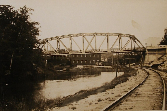
Newaygo, MI looking west along the old Pere Marquette Railway trackage on the right and the Muskegon River on the left both under the old M54 (now M-37 since 1926) bridge.
Jetlink wrote:I'm going to guess Newaygo. Based solely on the fact that historically M-54 used to run through the city before it was designated M-37.
Newaygo, MI looking west along the old Pere Marquette Railway trackage on the right and the Muskegon River on the left both under the old M54 (now M-37 since 1926) bridge.
Yes Newaygo. The water to the left is Penoyer Creek. Continuing along the track you would pass under M54 which is today M82. M54/M37 used to turn west after crossing river before turning north again after a half mile or so. The building in the distance was Rowe Manufacturing who produced things like wooden knobs for drawers and cabinets.
Yes, Newaygo. Penoyer Creek, which is just north of Muskegon River, run along the former Pere Marquette RR track both under M-54 (now M-82). Final run of the remaining old C&O railway passenger trains 25/26 between Grand Rapids and Traverse City, was made on October 29, 1966.
PatAzo wrote:Yes Newaygo. The water to the left is Penoyer Creek. Continuing along the track you would pass under M54 which is today M82. M54/M37 used to turn west after crossing river before turning north again after a half mile or so. The building in the distance was Rowe Manufacturing who produced things like wooden knobs for drawers and cabinets.
Nice... way more water in Penoyer Creek than I've seen in modern times.
The creek appears to have been dammed in this picture. There is a corrugated pipe discharging into the river where Rowe used to be. I've wondered if it's a remnant from a dam. This was the fourth picture at this spot I've found to use in the Where Is It thread.
At 15:10 Saturnalia has a nice drone shot of a southbound train passing under M82 and heading across the iver.
railrod1949 wrote:
Newaygo, MI looking west along the old Pere Marquette Railway trackage on the right and the Muskegon River on the left both under the old M54 (now M-37 since 1926) bridge.
Isn't this looking south?
https://www.flickr.com/photos/jimthias/
GRHC - you know every night I can imagine he is in front of his computer screen sitting in his underwear swearing profusely and drinking Blatz beer combing the RailRoadFan website for grammatical errors.
railrod1949 wrote:
Newaygo, MI looking west along the old Pere Marquette Railway trackage on the right and the Muskegon River on the left both under the old M54 (now M-37 since 1926) bridge.
Isn't this looking south?
This shot is most likely looking South at the M-82 / Curve Street bridge.
It is possible the shot could be looking West at the M-37 bridge north of town but there does not seem to be any evidence of a mill near that spot.
Standard Railfan wrote:
This shot is most likely looking South at the M-82 / Curve Street bridge.
It is possible the shot could be looking West at the M-37 bridge north of town but there does not seem to be any evidence of a mill near that spot.
No, it's definitely looking south. The tracks curving along Mill Creek don't provide that background view when looking west.
https://www.flickr.com/photos/jimthias/
GRHC - you know every night I can imagine he is in front of his computer screen sitting in his underwear swearing profusely and drinking Blatz beer combing the RailRoadFan website for grammatical errors.
J T wrote:No, it's definitely looking south. The tracks curving along Mill Creek don't provide that background view when looking west.
It's looking south with a touch of west. Penoyer Creek is on the left. The Muskegon River is out of view beyond the highway bridge. Here is a view from the bridge looking north.