Where Is It?

Posts that don't fit in the other train categories. Off Subject Chit Chat I tell you. :)
User avatar
DaveO
Read more, think more, post less
Posts: 1462
Joined: Thu Dec 14, 2017 12:57 pm
Location: Between here and there

Re: Where Is It?

Unread post by DaveO »

railrod1949 wrote:
DaveO wrote:
Pixl wrote:Well this location looks alot like a highway, but it did start it's life as a railroad crossing. See if you can name the spot and the original railroad.
I know where this is at.
But I will wait for someone to guess the location.
Then I will add what I found out.
It is here in Michigan?
The southwest corner of LIttle Clam Lake-now Lake Cadillac.

As for the railroad, all my good sources don't show it being a railroad at all.

But there is one online reference that talks about it https://clarkedigitalcollections.cmich. ... IN--------

And so the answer is built by the Cummer Logging Company whose corporate history is intermingled with the Cadillac and Northeastern Railway.
Built with material from a nearby Cobbs and Mitchell logging line that was removed. Given the proximity to their operation, this may have actually been a Cobbs and Mitchell line. The line basically followed the south, west and north shores of Little Clam Lake.

And so Pixl, I'm curious, how did you discover this almost obscure line? It's not on the Sanborn Maps I viewed. The USGS online topos aren't old enough to show that line. Historic Mapworks doesn't seem to have any maps with it showing.

railrod1949
Railroadfan...fan
Posts: 1317
Joined: Mon Oct 26, 2015 8:19 am
Location: Waterford, MI

Re: Where Is It?

Unread post by railrod1949 »

Yes, indeed, it's the M-115 (Sunnyside Drive) bridge over the southwest shore of Lake Cadillac at the jog with M-55 in Cadillac, Wexford County. In Pix's latest shot.

User avatar
James Sofonia
Grand Traverse Dinner Train 1996
Posts: 1701
Joined: Mon Mar 10, 2014 7:56 pm
Location: Traverse City, Michigan

Re: Where Is It?

Unread post by James Sofonia »

DaveO wrote: And so Pixl, I'm curious, how did you discover this almost obscure line? It's not on the Sanborn Maps I viewed. The USGS online topos aren't old enough to show that line. Historic Mapworks doesn't seem to have any maps with it showing.
Dave, you are correct on the location. Nice work.

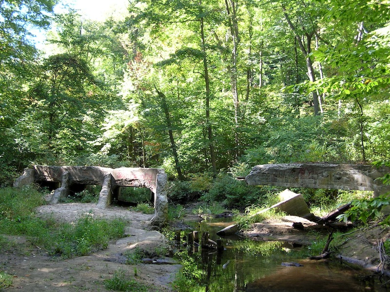
I read about it in the Traverse City Library some years ago and just thought about it again recently. The library moved to a new bulding and they discontinued the "Michigan Room" making it harder to find this stuff. But here is a clip from an article I found. It says it was the Cobbs and Mitchell logging railroad that built the first bridge across that area, later they filled it in to become a causeway. The railroad only used it a year or so. Later the crossing was converted to a highway. Here is the recent article I found.

Rails help build highway
One of the shortest term railroads in northern Michigan was the railroad that ran from Cadillac’s gravel pit to Lake Mitchell.
In 1891 Cobbs and Mitchell’s railroad to the southeast of Cadillac had completed its job of bringing logs from that area to the company’s mills in Cadillac. As the rails of the Cobbs and Mitchell logging railroad were taken up, they were laid along the south shore of Lake Cadillac as work progressed on a new roadway. The year before, a road had been built along the north side of Lake Cadillac from “Harristown” to the canal between the lakes and in 1891 a new road from Wood St. (now S. Mitchell) to Lake Mitchell was constructed. The Cobbs and Mitchell rails were extended from the gravel pit, near Maple Hill cemetery, southwestward to what was known as Hobart Highway and GR 4 I RR intersection. This would be near where present Sunnyside Drive crosses the Penn-Central railroad tracks. From there the rails hauled gravel westward along the south side of Lake Cadillac to the bay where they were extended over a long bridge. The roadway then joined at the canal with the 1890 roadway. Across the bay a bridge 1100 feet long was constructed to carry the new road as
well as the railroad during construction. The bridge rested on 200 cedar piles and contained 100,000 feet of hemlock lumber and timbers. The roadway was 16 feet wide and had substantial railings. The greatest depth of water at the bridge in 1891 was 12 feet. The bridge was later replaced in more modern days with a stone, iron furnace slag and dirt causeway topped with concrete paving. It is now used by highways M-115 and M-55. Old records do not indicate what was done with the rails when the roadway was completed or the exact date when the rails were removed but it is believed it was at the end of 1891 or early in 1892, giving the railroad about one year of life.

User avatar
SteveHiuzenga
Railroadfan...fan
Posts: 799
Joined: Wed Aug 01, 2007 7:10 pm
Location: Zeeland

Re: Where Is It?

Unread post by SteveHiuzenga »

Can you name who used this bridge?
bridge.jpg

User avatar
James Sofonia
Grand Traverse Dinner Train 1996
Posts: 1701
Joined: Mon Mar 10, 2014 7:56 pm
Location: Traverse City, Michigan

Re: Where Is It?

Unread post by James Sofonia »

SteveHiuzenga wrote:Can you name who used this bridge?

I'd say it was automobiles that used the bridge and the rails you see are simply reinforcing the concrete.
Attachments
bridge.jpg

PatAzo
Railroadfan...fan
Posts: 1371
Joined: Tue Feb 26, 2013 9:20 pm

Re: Where Is It?

Unread post by PatAzo »

SteveHiuzenga wrote:Can you name who used this bridge?
bridge.jpg
More of a culvert than a bridge. But assuming it was for railroad use, given the light construction I'd say one of the interurban's around Grand Rapids.

User avatar
DaveO
Read more, think more, post less
Posts: 1462
Joined: Thu Dec 14, 2017 12:57 pm
Location: Between here and there

Re: Where Is It?

Unread post by DaveO »

PatAzo wrote:
SteveHiuzenga wrote:Can you name who used this bridge?
bridge.jpg
More of a culvert than a bridge. But assuming it was for railroad use, given the light construction I'd say one of the interurban's around Grand Rapids.
I agree with that assessment.

Who used it? Either the Michigan United Railway/Michigan Electric Railway or the GRGH&M Railway.

User avatar
James Sofonia
Grand Traverse Dinner Train 1996
Posts: 1701
Joined: Mon Mar 10, 2014 7:56 pm
Location: Traverse City, Michigan

Re: Where Is It?

Unread post by James Sofonia »

Mr. Steve Hiuzenga, can you make a move on your post? Acknowledgement of the guesses or add a hint. Thank you.

User avatar
SteveHiuzenga
Railroadfan...fan
Posts: 799
Joined: Wed Aug 01, 2007 7:10 pm
Location: Zeeland

Re: Where Is It?

Unread post by SteveHiuzenga »

full bridge.jpg
1914.jpg
pilings.jpg
Ack! much to my embarrassment, ya all may be right about the road...here is the full bridge, the pilings next to the bridge where the tracks actually ran...and the date the bridge was made....

User avatar
~Z~
Sofa King Admin
Posts: 12933
Joined: Tue Oct 12, 2004 2:14 pm
Location: Grand Rapids, MI
Contact:

Re: Where Is It?

Unread post by ~Z~ »

SteveHiuzenga wrote:Can you name who used this bridge?
bridge.jpg
Is this JT's interurban bridge on the south side of Holland that used to go to Saugatuck? I want to say along 66th St?
Webmaster
Railroad photos on Railroadfan.com

User avatar
SteveHiuzenga
Railroadfan...fan
Posts: 799
Joined: Wed Aug 01, 2007 7:10 pm
Location: Zeeland

Re: Where Is It?

Unread post by SteveHiuzenga »

Yes Sir...Sanctuary Woods Preserve on the south side of Holland....

User avatar
DaveO
Read more, think more, post less
Posts: 1462
Joined: Thu Dec 14, 2017 12:57 pm
Location: Between here and there

Re: Where Is It?

Unread post by DaveO »

SteveHiuzenga wrote:Yes Sir...Sanctuary Woods Preserve on the south side of Holland....
So it would be the Saugatuck, Douglas and Lake Shore.

Not sure of the exact location of that bridge, but I don't believe the line closely paralleled a road outside of the towns.
Good chance the pilings were the original bridge and replaced circa 1914 by the box culvert pictured.

https://books.google.com/books?id=BUE_A ... &q&f=false

User avatar
James Sofonia
Grand Traverse Dinner Train 1996
Posts: 1701
Joined: Mon Mar 10, 2014 7:56 pm
Location: Traverse City, Michigan

Re: Where Is It?

Unread post by James Sofonia »

DaveO wrote: Good chance the pilings were the original bridge and replaced circa 1914 by the box culvert pictured.
I can imagine the remaining posts carried an interurban line. But the 1914 box culvert wouldn't carry anything, maybe not even the autos of the time. They must have salvaged some of the rails for re-enforcement of the structure being burried in the concrete. An interesting find Steve.

User avatar
Jochs
Iron Horse Whisperer
Posts: 7288
Joined: Sat Feb 13, 2010 4:52 pm
Location: On my laptop!

Re: Where Is It?

Unread post by Jochs »

SteveHiuzenga wrote:Can you name who used this bridge?
bridge.jpg
You? Image
Jeff O.
Celebrating 11 years dial-up free!

(18:36:45) MagnumForce: Railfanning is way more fun when you stop caring about locomotives and signals
(19:11:29) cbehr91: I can't believe I'm +1ing Brent but +1

User avatar
Michael
Railroadfan...fan
Posts: 10846
Joined: Sun Sep 12, 2010 2:52 pm
Location: Plymouth, Michigan

Re: Where Is It?

Unread post by Michael »

Cool spot and history. I found another photo of the bridge
Image

User avatar
~Z~
Sofa King Admin
Posts: 12933
Joined: Tue Oct 12, 2004 2:14 pm
Location: Grand Rapids, MI
Contact:

Re: Where Is It?

Unread post by ~Z~ »

Where be it?
Looks like a spot where the railroad used to go under this very main road, but was filled in with dirt after the railline was torn up. ROW is between the sets of trees on right side of photo.
Attachments
wherebeit10.JPG
Webmaster
Railroad photos on Railroadfan.com

railrod1949
Railroadfan...fan
Posts: 1317
Joined: Mon Oct 26, 2015 8:19 am
Location: Waterford, MI

Re: Where Is It?

Unread post by railrod1949 »

~Z~ wrote:Where be it?
Looks like a spot where the railroad used to go under this very main road, but was filled in with dirt after the railline was torn up. ROW is between the sets of trees on right side of photo.
Somewhwere in west Michigan. Look like the shot above is looking southwest.

GP30M4216
Saver of all History
Posts: 4819
Joined: Wed Oct 27, 2004 10:35 pm
Location: Feel the Zeel, MI
Contact:

Re: Where Is It?

Unread post by GP30M4216 »

So it would be the Saugatuck, Douglas and Lake Shore.

Not sure of the exact location of that bridge, but I don't believe the line closely paralleled a road outside of the towns.
Good chance the pilings were the original bridge and replaced circa 1914 by the box culvert pictured.
The original route of the Grand Rapids, Holland and Lake Shore (later Grand Rapids, Holland & Chicago, and then Michigan Electric) from Holland to Saugatuck was built in 1898-99 and the north end of the line going south from Holland was realigned in 1913-14. However, I thought that the original alignment was the one running south near 66th Street (location of this photo), and the later 1913 alignment was situated further east...not immediately beside it, but between 64th and 62nd. The date on this photo would seem to indicate the reverse.....I'll have to check my records at work (Saugatuck-Douglas History Center). Either way, hiking out to this bridge is on my bucket list! Thanks for sharing the great photos!

User avatar
James Sofonia
Grand Traverse Dinner Train 1996
Posts: 1701
Joined: Mon Mar 10, 2014 7:56 pm
Location: Traverse City, Michigan

Re: Where Is It?

Unread post by James Sofonia »

Steve3.jpg

railrod1949
Railroadfan...fan
Posts: 1317
Joined: Mon Oct 26, 2015 8:19 am
Location: Waterford, MI

Re: Where Is It?

Unread post by railrod1949 »

~Z~ wrote:Where be it?
Looks like a spot where the railroad used to go under this very main road, but was filled in with dirt after the railline was torn up. ROW is between the sets of trees on right side of photo.
More hints please!

Post Reply