Page 2 of 2
Re: New Ohio Online Rail Map
Posted: Fri Aug 16, 2019 8:23 am
by ~Z~
cr6903 wrote: The other East/West line in town is the original main line of the CCC&STL which went down through the middle of town and over the Miami River.
Where the old line ran on the east side of town is now Tawana Park. Neat entrance to the park follows the ROW on a narrow strip along a lake. Lots of old tow paths for the canal is in the park as well that I've mountain biked. Site says the line was relocated to the new alignment in the 1920's.
http://www.sidneyoh.com/Parks/parks-tawawa-history.asp
Re: New Ohio Online Rail Map
Posted: Fri Aug 23, 2019 11:17 pm
by chapmaja
I found another one of interest.
Toledo Ohio, tracks to the Cherry Street Station. These tracks appear to be missing from the map as abandoned tracks.
My question is where did these tracks actually run? The information I can find indicates the passenger station was at the eastern corner of Seneca and Cherry St. This would put it at the location that now houses Reliable Belting and Trans (per Google Maps). The freight station was next to the passenger station. I know the passenger station was removed in 1964, but when were the tracks removed to this location. Also, were the tracks an extension of the tracks that currently end at the Libby Glass facility next to 280 or was there another track that extended to this location? There is no line on the Ohio Rail Map as abandoned running to where the Cherry St station would have been. Finally, assuming I can correct, and the tracks did run past Libby to the Cherry St. Station, when were these tracks removed. I thought, during the Michigan Interstate legal battles, the GP-35's were stored at the very end of the AA trackage, which would have been near the location of Cherry St. Station's footprint.
Re: New Ohio Online Rail Map
Posted: Mon Aug 26, 2019 1:45 pm
by blueheron13
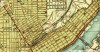
As far as the actual location of the rail line, I looked on the USGS Historical Topographic Map Explorer and snipped this image, but I don't know the answers to your other questions:
Re: New Ohio Online Rail Map
Posted: Mon Aug 26, 2019 8:29 pm
by bdconrail29
chapmaja wrote:I found another one of interest.
Toledo Ohio, tracks to the Cherry Street Station. These tracks appear to be missing from the map as abandoned tracks.
My question is where did these tracks actually run? The information I can find indicates the passenger station was at the eastern corner of Seneca and Cherry St. This would put it at the location that now houses Reliable Belting and Trans (per Google Maps). The freight station was next to the passenger station. I know the passenger station was removed in 1964, but when were the tracks removed to this location. Also, were the tracks an extension of the tracks that currently end at the Libby Glass facility next to 280 or was there another track that extended to this location? There is no line on the Ohio Rail Map as abandoned running to where the Cherry St station would have been. Finally, assuming I can correct, and the tracks did run past Libby to the Cherry St. Station, when were these tracks removed. I thought, during the Michigan Interstate legal battles, the GP-35's were stored at the very end of the AA trackage, which would have been near the location of Cherry St. Station's footprint.
You might be forgetting interurban lines again.
Re: New Ohio Online Rail Map
Posted: Mon Aug 26, 2019 9:01 pm
by chapmaja
blueheron13 wrote:As far as the actual location of the rail line, I looked on the USGS Historical Topographic Map Explorer and snipped this image, but I don't know the answers to your other questions:
That actually helps a lot. The tracks that run to Libby Glass are actually the former W&LE tracks. There appear to be three lines that actually went to and ended at Cherry St. The southern most, the one with the remaining section is the W&LE line. The middle of the three, was the Ann Arbor, while the Toledo Terminal also had a line running to Cherry St, next to the AA's tracks. The AA and TT tracks appeared to curve north and enter the current AA mainline at a point just north of Manhatten Ave.
That are where the Chrysler plant is now sure looked different 100 years ago. You had the line going from the AA mainline to Cherry St. The AA's Ottawa yard was still where it is today. Where the Jeep plant is, was a yard belonging to either the Lake Shore and Michigan Southern, or the Michigan Central which ran across the now Jeep Property and went SE along the current AA line goes then went into a cluster of tracks at the south end of where the AA yard south of Manhattan currently sits.
Toledo was a very different place in 1900 and that was before the TT was actually in existence, which didn't start until 1907.
Re: New Ohio Online Rail Map
Posted: Wed Jan 08, 2020 9:21 pm
by 937TrainFan
Looks like ORDC got a new website. If anyone is having issues finding out where the interactive map application went, here are a couple links.
https://rail.ohio.gov/wps/portal/gov/or ... ap-request
You can access the application from the Ohio Rail Map section of the website and clicking on GIS Mapping Tool in the "External Resources" window on the right side of the page (or bottom of the page if you're on mobile device).
Here is a direct link to the application that you can save as a bookmark to your browser:
https://gis3.dot.state.oh.us/OhioRail/
Hope everyone is having a safe and warm new year.
Re: New Ohio Online Rail Map
Posted: Sun Nov 01, 2020 11:18 am
by BigBob’sUsedCarLot
Pretty neat! Obviously you can view pdf on your device, but you can also request a physical map. I requested one and I had a shipping envelope arrive in the mail 3 days later with 2 maps! Maybe something neat to frame?